
Survival
7 Navigation Skills Every Explorer Needs (No Phone Needed)
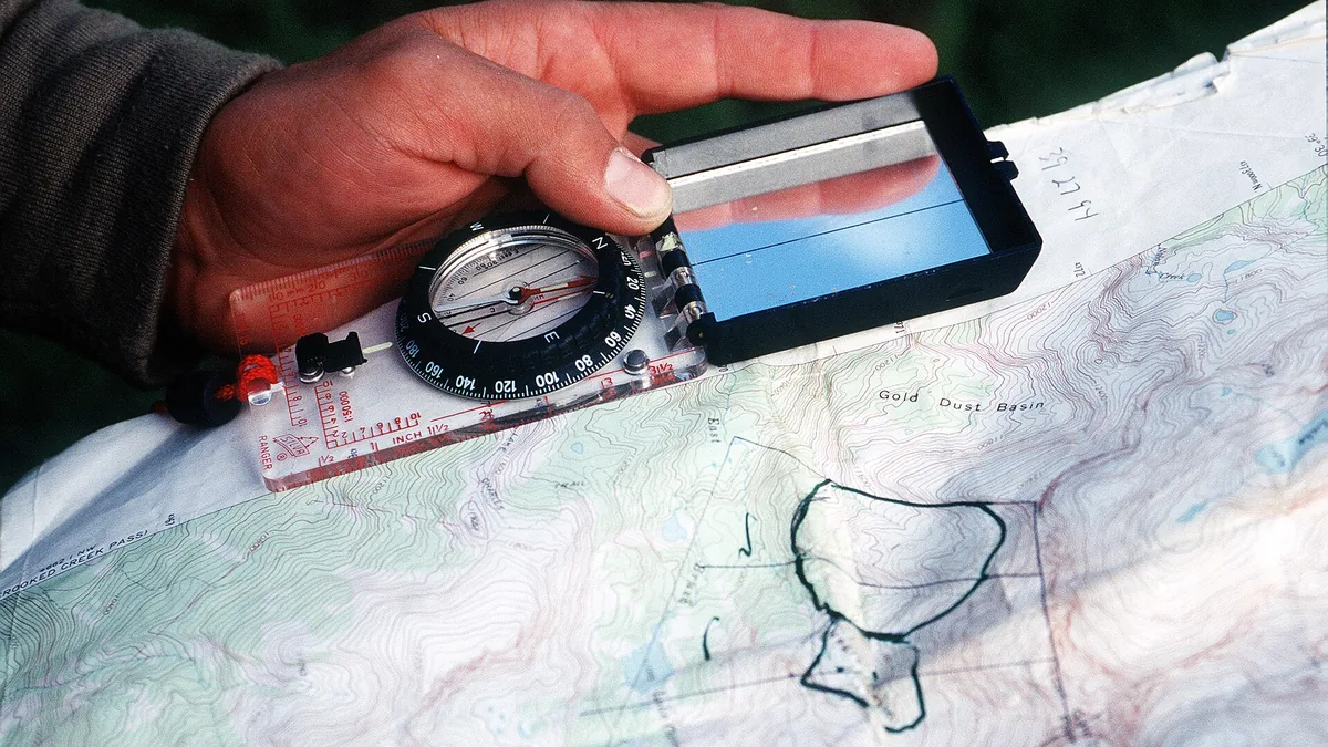
Key takeaways
- Contour lines reveal terrain: close lines mean steep ground.
- Learn to take bearings and adjust for magnetic declination.
- Terrain association matches what you see to what the map shows.
- The best navigation skill is staying found by checking your map often.
Smartphones have made navigation almost effortless, which is exactly why the skill has quietly atrophied. Batteries die in the cold, screens crack on rocks, water gets in, and signal disappears in valleys and under forest canopy. Every explorer should be able to find their way without a phone, and doing so requires only seven learnable skills: map reading, compass work, terrain association, pace counting, natural cues, backtracking, and the discipline of staying found.
Map reading: contours and shapes
A topographic map represents three dimensions with lines that connect points of equal elevation. Contour lines packed tightly together mean steep ground; widely spaced lines mean a gentle slope; lines that merge into a solid band indicate a cliff. Evenly spaced concentric rings mark a hill, and a V-shaped contour points uphill when it traces a valley and downhill when it traces a ridge spur.
Learn to recognise three shapes before you rely on a map in the field: valleys, ridges, and saddles. Saddles — the low points between two summits — are where passes and trails almost always run. Practise by matching a hill you know to its contours on paper.
Compass work: bearings and declination
A compass gives you direction relative to magnetic north. Combined with a map, it lets you take a bearing to a visible object, follow a heading, and fix your position by triangulating from two or three known landmarks. A basic baseplate compass is all a hiker needs.
The step beginners skip is magnetic declination — the difference between magnetic north and true north, which varies by region and is printed on the map margin. Ignore it and a bearing can be wrong by several degrees, which over a kilometre is a very different hillside. Learn your local declination and adjust the bearing before you walk.
Terrain association
Terrain association means matching what you can see to what is drawn. Identify a summit, a river junction, a lake, a distinctive spur, or a road bend, then confirm they relate to each other the way the map shows. One matching feature can be coincidence; three is a position.
Do it deliberately rather than continuously, and always at junctions and after a long climb. A useful habit is to look back frequently as you walk, because the return trip looks nothing like the outward one.
Pace counting
Pace counting estimates distance travelled when there is nothing to see. Measure your natural pace by walking a known 100 metres and counting every other step — roughly 60 to 70 double-paces for most adults on flat ground. Then count as you walk and you can track distance even in fog, forest, or featureless terrain.
Combine pace counting with a compass bearing and you can navigate accurately through a whiteout or across open moorland, which is precisely where GPS units fail most often.
Natural navigation
The sun, stars, and weather patterns offer rough direction cues. In the northern hemisphere the sun rises in the east and sets in the west, tracking through the southern sky, and at night Polaris sits close to true north. In the southern hemisphere, the Southern Cross points toward south. Shadows are shortest at midday and point away from the sun.
Vegetation, prevailing wind, and snow patterns can hint at direction, but they are unreliable and should be treated as confirmation rather than primary evidence. Use them when you have already narrowed down where you are.
Backtracking and route planning
The safest response to uncertainty is to return to the last point where you were certain, rather than to continue and hope. Before you leave, study the route and mark the decision points where a wrong turn is possible. On the trail, note features you will need in reverse.
Good route planning prevents most navigation problems from arising. A plan that includes a turnaround time, an alternative route, and a bad-weather option means the decision is already made when conditions are worst.
Staying found
The best navigation skill is not getting lost in the first place. Check the map regularly rather than only when confused, keep track of how long you have been walking, and travel at a pace that lets you observe where you are. If visibility drops, stop and reassess rather than pressing on and hoping the trail reappears.
Avoid the two classic errors: walking past a junction without checking, and assuming a path is the one you planned simply because it is a path.
Practise before you need it
Navigation skills fade without use. Take a map and compass to a local park, set a bearing, follow it for a few hundred metres, and count your paces. Practise on trails you already know so that the mechanics become automatic before the day you depend on them. Confidence in navigation comes almost entirely from repetition, and the cost of practising is nothing.
Conclusion
Phones are useful tools, not backup plans. Learn to read contour lines as terrain, adjust a bearing for declination, confirm your position with three landmarks, count paces when there is nothing to see, and turn back when you are unsure. These seven skills take a few weekends to learn and will serve you for the rest of your travelling life — including on every occasion the battery runs out.
Keep reading
The Best Tents for Wild Camping in 2026: 8 Shelters Tested in Real Weather
Compare the best wild camping tents of 2026 on weight, weather resistance and pack size. Real picks for solo trekkers, pairs and shoulder-season trips.
How to Build a Survival Shelter in the Wild: 6 Designs That Actually Keep You Dry
Six wilderness shelter designs — lean-to, debris hut, tarp configurations and snow shelters — with the situation each one is actually built for.
The Best Headlamps for Night Hiking and Camping in 2026
Lumens, beam pattern, battery life and red-light modes explained. Picks for the best hiking headlamps at every budget, with what actually matters.
