
Natural Wonders
Europe's Deepest Canyon Is Not Where You Think: The Tara River Gorge
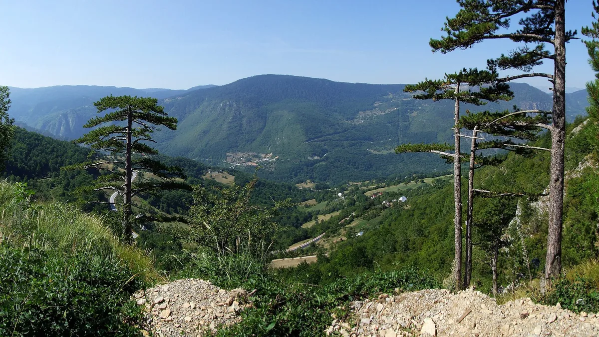
Key takeaways
- Tara Gorge reaches roughly 1,300 meters of relief over a comparatively short distance.
- It was carved by a river, not by ice — that is why its walls are near-vertical.
- Depth ranking depends on whether you measure from rim to river or from surrounding plateau.
- Rafting season and road access are both short; timing matters more than at famous canyons.
Ask most people to name Europe's deepest canyon and they will guess somewhere in the Alps, or perhaps one of the Norwegian fjords. The answer is a river gorge in the mountains of Montenegro that reaches roughly 1,300 metres from rim to water, cuts through a national park, and is seen by a fraction of the people who visit comparable gorges elsewhere. The Tara River Canyon is not undiscovered — it is simply not on the standard European itinerary, and that is what makes it worth understanding.
How deep is it really
Depth figures for canyons are quoted inconsistently, and that is the main reason the ranking looks surprising. The Tara gorge is commonly described as reaching about 1,300 metres at its deepest point, measured from the highest rim down to the river surface. By that measure it is among the deepest river gorges in Europe and frequently cited as the deepest.
The comparison problem is that some famous gorges are quoted using a different baseline — measuring from the surrounding plateau, or from the highest nearby peak rather than the immediate rim. A canyon incised into a high plateau will produce a larger number simply because the surrounding terrain is high, even if the gorge itself is shallower from rim to river. Both measurements are legitimate; they answer different questions.
What is not ambiguous is the visual impression. Standing on the rim of the Tara, the opposite wall is a near-vertical drop of extraordinary height, and the river at the bottom is a thin ribbon. The narrowness of the gorge relative to its depth is what makes it read as so dramatic — the walls are close enough that you perceive the full height at once.
How a river cuts a canyon this deep
The Tara gorge is a river canyon, which means it was cut by water rather than by ice. That distinction explains its shape. Glacial valleys are broad and U-shaped, widened and straightened by moving ice. River canyons in resistant rock are narrow and V-shaped, cut downward by the river carrying sediment as an abrasive.
Downcutting requires two things: a river with enough energy to erode its bed, and rock that is resistant enough to hold near-vertical walls once cut. Limestone dominates this region, and limestone behaves well for canyon formation — it is hard enough to stand in cliffs, and it is soluble, so water simultaneously cuts mechanically and dissolves the rock along fractures.
The third requirement is time combined with uplift. As the land rises, the river keeps cutting to maintain its gradient, and the result is a canyon that deepens as the surrounding terrain rises. This is why the deepest canyons are typically found in actively rising mountain belts rather than in old, stable ones.
Karst processes add a further layer. Water that disappears into the limestone re-emerges as springs, sometimes in the canyon walls themselves, and the underground drainage means much of the region's water moves invisibly. The visible river is only part of the system.
The river itself
The Tara is a cold, clear, fast-flowing river that runs through the gorge for a substantial distance. Its water comes largely from snowmelt and karst springs, which is why it stays cold year-round and why its clarity is exceptional.
Clarity has a practical consequence: the water is deceptively deep. A river you can see the bottom of is a river people underestimate, and the Tara has pools that are considerably deeper than they appear. Cold water at this temperature also means that immersion is a genuine hazard rather than an inconvenience.
The flow is highly seasonal. Spring snowmelt produces high, fast water; late summer produces lower, warmer and more technical conditions. Both are runnable commercially, and they are very different experiences on the water.
How to actually see it
The road along the rim is the accessible option, and there are multiple viewpoints where you can park and walk a few minutes to the edge. This gives you the full vertical impression with essentially no effort, and for many visitors that is the right way to see it.
The bridge crossing the gorge is the other classic viewpoint, and it puts you directly above the river with walls rising on both sides. It is also the location of the commercial rafting and zipline operations, so it is the busiest point in the canyon.
Rafting is the way to see the gorge from the bottom, and it is the experience that converts people. From the water the walls close in completely, the scale becomes physical rather than visual, and the sections of the river run through rapids that are genuinely engaging without requiring prior experience on most commercial trips. Run it with a licensed operator; the river is cold, remote, and not a place to improvise.
Hiking options exist on the rim and into the surrounding national park, but routes into the canyon itself are limited and demanding. The walls are steep, the terrain is rough, and route-finding in the gorge is serious work. Treat the gorge as something to look into and float through rather than something to descend casually.
When to go and what the seasons do
The canyon is in the Dinaric mountains, which means it receives substantial snow in winter and the access roads at elevation can be affected. The practical season runs roughly from late spring to early autumn.
Late spring and early summer give the highest water and the most dramatic river, plus full snowmelt flows in the tributary waterfalls that run down the canyon walls. This is the best time for rafting and for photography of the gorge in full flow.
Late summer gives lower water, warmer air and more stable weather, which suits hiking and the rim viewpoints better. The trade-off is that some seasonal waterfalls reduce to nothing.
Autumn is the quietest and arguably the most beautiful, with beech and mixed forest changing colour on the upper slopes against grey limestone. It is also when the weather starts to turn and when some operations close for the season, so check what is running before you commit.
The surrounding region
The canyon sits within a national park that is part of a larger protected mountain area. The terrain around the rim includes high pastures, forest, glacial features and a network of mountain lakes, which makes the region worth several days rather than a single viewpoint stop.
The mountain massif above the canyon is a serious hiking destination in its own right, with marked trails, mountain huts and summit routes. Combining a rim visit with a day or two walking in the massif is the best way to justify the journey.
The region is also notable for its river and forest ecology. The canyon walls support plant communities on ledges that have never been grazed or logged, and some of the forest in the wider area is old-growth by European standards, which is rare on the continent.
Practically, the area is small-town and rural. Accommodation is concentrated in a few settlements near the canyon, booking ahead in summer is advisable, and having a vehicle gives you far more options than relying on public transport.
How it compares to the world's famous canyons
Set against the very large canyons of the world, the Tara is modest in total length and comparable in depth — which is not the contradiction it appears to be. The famous canyons of the American Southwest are enormous because they were cut through a high plateau over a very long period by a very large river. Their scale is a product of the plateau's elevation and the river's discharge, and their depth, while immense, is distributed across a wide landscape with a great deal of space between the rims.
The Tara's depth is concentrated. The gorge is narrow relative to its height, and in places the walls rise almost uninterrupted from water to rim. That ratio is what produces the visual impression of depth rather than of size, and it is why a gorge that is not the longest or the widest can still read as the most vertiginous.
There is a second difference in vegetation. The large desert canyons are arid and their walls are largely bare rock and scrub. The Tara cuts through a wet, forested mountain region, and its walls carry substantial tree cover on the ledges and upper slopes. Forest against grey limestone changes the character of the place completely, and it is part of why the canyon looks so different from the images people associate with the word.
Conclusion
The Tara River Canyon is Europe's deepest gorge by the measure that matters — rim to water — and it is far better than its obscurity suggests. It was cut by a river through uplifted limestone, which is why the walls are steep and close and the scale reads instantly. See it from the rim viewpoints for the vertical, cross the bridge for the classic view, and get on the water with a licensed operator for the version nobody forgets. Come in late spring for full flow or autumn for colour and quiet, and give the surrounding mountain park a couple of days rather than treating the canyon as a single stop.
Keep reading
Beyond Machu Picchu: 8 Inca Sites Almost Nobody Visits
Choquequirao, Wari terraces and fortress complexes that see a fraction of Machu Picchu's visitors. Where they are and what the hike involves.
New Zealand's Great Walks: The Four Almost Nobody Books
Most hikers book the Routeburn and Milford. These four Great Walks get a fraction of the traffic with the same alpine and coastal scenery.
The Lakes That Vanish Every Year and Come Back: Seasonal Lakes Explained
Karst sinkholes, glacial outbursts and evaporating basins create lakes that drain and refill on a schedule. Where to see them and why it happens.
