
Destinations
The Last Roadless Areas in the Lower 48: Where America Still Has No Roads
Key takeaways
- Roadless does not mean inaccessible; it means you arrive on foot or on water.
- The largest roadless blocks in the Lower 48 are in Idaho, Nevada and Montana.
- Navigation skill is the entry fee — trails are sparse and often unmaintained.
- These places are quiet because of effort, not because of distance.
The continental United States still contains very large areas with no roads in them at all. Not gravel tracks — no roads, no motorised access, in some cases no trails either. These places are mapped, protected and legally defined, and they add up to tens of millions of acres. They are quiet not because they are far away but because reaching them requires effort that most people never make, and that effort is precisely the filter that keeps them quiet.
What roadless actually means
Roadless is a specific condition, not a poetic one. A roadless area has no improved road suitable for motorised vehicles passing through it. It does not mean inaccessible — most of these areas are crossed by trails, approached by water, or entered from a trailhead where the road simply stops.
It is also not the same as a designated wilderness area, though the two overlap substantially. Wilderness designation is a legal status with specific restrictions on motorised and mechanical use. Roadless is a physical description. Some roadless land is not designated wilderness, and some designated wilderness contains old roads that are no longer maintained and are slowly reverting.
The practical consequence for a visitor is simple: everything you bring in, you carry, and everything that goes wrong, you walk out from. There is no driving to a viewpoint. If you want to see the middle of one of these places, you go on foot for several days, and that is the entire reason they remain as they are.
Why these areas survived
Every one of these places has a history of being nearly developed. Timber access, mining claims, hydropower schemes, grazing allotments and road proposals have all been advanced in most of them, and most were fought off over decades. What exists now is the result of specific decisions made at specific times, not of the land being too difficult to bother with.
The areas that survived are generally the ones where the economics were marginal. Steep ground, long distances from mills or markets, and poor timber quality all made development unattractive enough that protection was achievable. That is a slightly unromantic explanation, but it is why the largest blocks are where they are.
Understanding this changes how you see them. These are not landscapes that were never wanted; they are landscapes that were repeatedly proposed for something else and repeatedly defended.
Where the largest blocks are
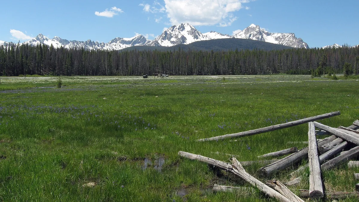
The biggest continuous roadless terrain in the Lower 48 is concentrated in the northern Rockies and the Great Basin. Idaho, Montana and Nevada hold the largest expanses, with Idaho alone containing multiple areas measured in millions of acres.
In Idaho, the large wilderness blocks in the centre of the state form one of the biggest stretches of roadless country in the continental United States. The terrain is deep river canyons, high forested ridges and an enormous amount of space between trails. This is grizzly country, it has very few bridges, and the river crossings are the reason access is seasonal and demanding.
Montana holds several of the most rugged wilderness ranges in the country, with dramatic limestone topography, high passes and a genuine sense of scale. The northern ranges in particular combine roadless area with serious vertical relief, which is a combination that produces both spectacular walking and genuinely difficult navigation.
Nevada is the surprising entry. It is not the first state people associate with wild country, but it holds some of the largest designated wilderness areas in the Lower 48. They are desert and mountain rather than forest — long basin-and-range ridges separated by dry valleys — and they are among the emptiest places in the country, with water being the defining constraint rather than terrain.
The Pacific Northwest and California hold substantial roadless country in the Cascades and the Sierra, characterised by volcanic terrain in the north and high granite in the south. Several of the most famous long-distance trails pass through them, which means some sections are busy and others, a few miles away, are not.
Getting in: how access actually works
Access is the whole exercise. Roads around these areas stop at trailheads, and the trailhead is often several hours of driving from the nearest town, with the last stretch on unpaved surface that requires appropriate clearance and a spare tyre.
Once on foot, the trail network is often sparser than in more visited mountain areas. Some trails are maintained annually, some every few years, and some are essentially routes rather than paths. Blowdown — trees fallen across the trail — is common and crossing or cutting your way through it is a routine part of travel.
River crossings are the serious constraint in the northern Rockies. Many crossings are unbridged, and during spring runoff a crossing that is trivial in August is genuinely dangerous in June. Learn to assess a crossing, know how to cross safely as a group, and be prepared to wait a day or turn around.
Trailheads themselves are remote. Vehicle break-in and vandalism happen, fuel is a long way away, and mobile coverage is effectively absent. Plan your transport as carefully as your route.
Navigation is the real entry fee
These are not places where you can follow a well-marked path and a phone. Trails fade, junctions are unsigned, and the combinations of forest cover, steep terrain and weather make it easy to lose a route. Navigation skill — map, compass, and the ability to relate the two to the ground — is not optional equipment here.
Carry a paper map and a compass as your primary system, and know how to use them before you go. Carry a GPS device or a phone with downloaded offline maps as a secondary system, with enough battery and a way to recharge. Satellite communicators work well in this terrain where phones do not, and they are the difference between an incident and a serious incident.
The specific skill that matters most is knowing when you no longer know where you are. In dense forest on steep ground, people continue in a direction long after they should have stopped and reassessed. Establishing your position regularly, and being willing to stop, backtrack and re-locate, is what keeps a navigation error from becoming an emergency.
Water, season and the short window
Season length is short. Snow closes the high country for most of the year in the Rockies and the Sierra, and the accessible window is roughly July to September at elevation. At lower elevations in the Great Basin the constraint flips: summer heat makes travel dangerous, and spring and autumn are the viable windows.
Water availability varies enormously. In the northern Rockies water is generally plentiful but needs filtering. In the Nevada ranges it may be a long distance between sources, and some sources marked on maps are seasonal. Carry more water capacity than you would elsewhere and know your next reliable source before leaving the last one.
Weather at elevation changes fast in every one of these regions. Afternoon thunderstorm patterns in the Rockies and the desert Southwest produce lightning exposure above treeline, and snow is possible in the high country in any month of the year. Build your day around being off exposed ground in the afternoon.
Wildlife you need to plan around
Several of these areas hold grizzly bear populations, and travelling in grizzly country requires specific behaviour: carry bear spray where it is permitted and know how to use it, store food properly, make noise on overgrown trails, and never approach an animal or a carcass.
Proper food storage is not optional in bear country. That means a hard-sided canister or a properly executed hang, depending on local regulation and the terrain. Check the specific requirement for the area you are entering, because rules differ between jurisdictions.
Even outside grizzly range, these areas hold black bears, mountain lions, wolves and a great deal of large ungulate. Seeing any of them is a privilege; feeding any of them, deliberately or by leaving food accessible, is what eventually causes them to be removed.
Conclusion
Roadless country in the Lower 48 is larger and emptier than most people imagine, and it is concentrated in Idaho, Montana, Nevada and the high ranges of the West. It is quiet because of effort rather than distance: long approach drives, rough trailheads, unbridged rivers, fading trails and a real requirement to navigate. Go in the short summer window at elevation, plan every water source, carry navigation you can use without a signal, and behave properly in bear country. Do that and you can walk for a week across country that looks exactly as it did before the roads arrived.
Keep reading
Beyond Machu Picchu: 8 Inca Sites Almost Nobody Visits
Choquequirao, Wari terraces and fortress complexes that see a fraction of Machu Picchu's visitors. Where they are and what the hike involves.
Europe's Deepest Canyon Is Not Where You Think: The Tara River Gorge
The Tara River Canyon cuts deeper than most famous European gorges. How it formed, how it compares to the world's big canyons and how to see it.
New Zealand's Great Walks: The Four Almost Nobody Books
Most hikers book the Routeburn and Milford. These four Great Walks get a fraction of the traffic with the same alpine and coastal scenery.
