
Natural Wonders
How Glaciers Carve Valleys: Reading the Landscape They Leave Behind
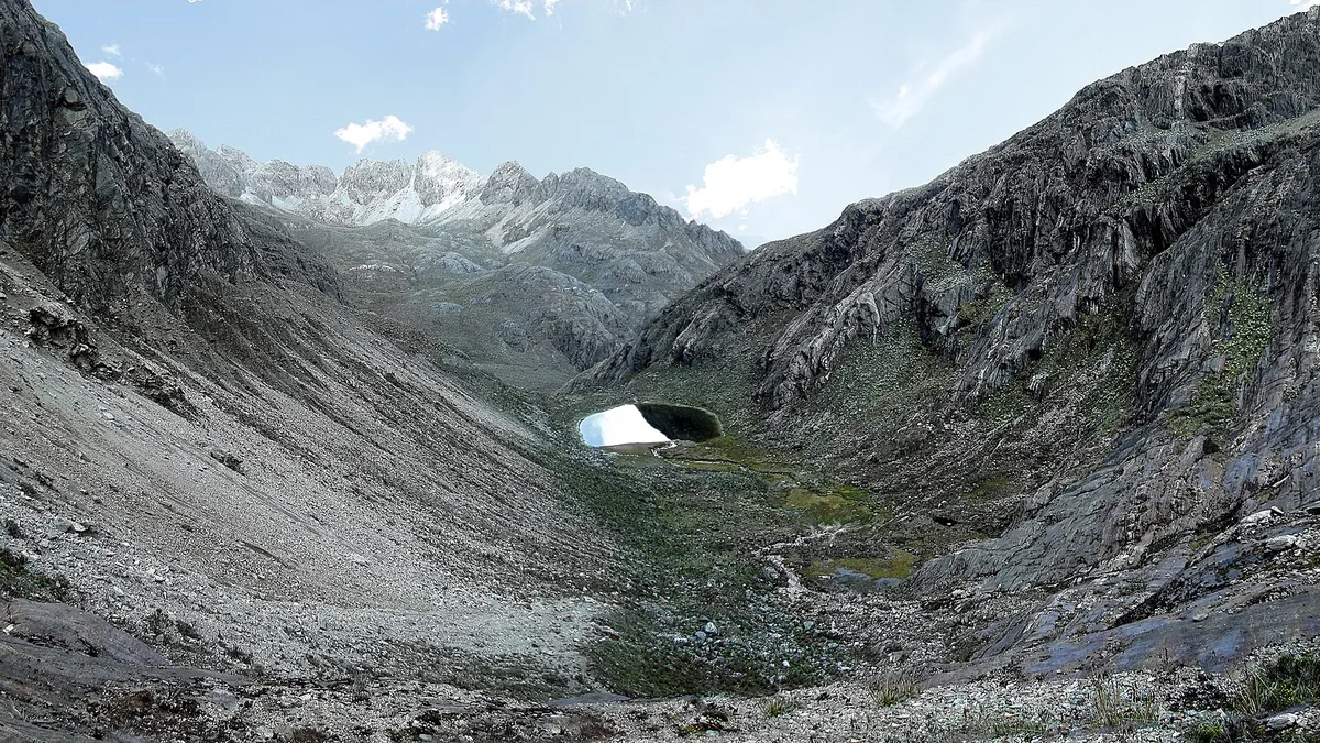
Key takeaways
- A U-shaped cross-section is the clearest signature of glacial erosion versus river erosion.
- Hanging valleys exist because main glaciers cut deeper than their tributaries.
- Moraines are the debris record of where a glacier paused or ended.
- Erratics are rocks that do not belong, and they map where the ice came from.
Glaciers are the most powerful land-shaping force most people will ever stand inside the results of. They quarried rock, moved it tens of kilometres, and left behind a landscape with a recognisable signature that persists for thousands of years after the ice has gone. Once you know what to look for, you can stand in a valley anywhere in the world and read what the ice did, which direction it came from, how thick it was and roughly when it left. Here is the vocabulary.
U-shaped versus V-shaped: the first thing to look at
The most useful single observation is the cross-section of the valley. A river cuts downward and produces a V: narrow at the bottom, widening upward, with slopes that meet in a point. Debris falls to the bottom and the river carries it away, so the profile stays angular.
A glacier cuts downward and sideways at once. Ice fills the valley, presses against the walls, and grinds them back. The result is a U: a broad flat or rounded floor with steep walls rising directly from it, and often a distinct shoulder where the grinding stopped. Where a valley has that shape, ice was there.
This is the tell that separates glacial from fluvial landscapes anywhere in the world, and it is visible from a single viewpoint. A hanging valley or a flat floor between steep walls in a mountain region is almost always glacial.
The other giveaway is the valley's plan view. Rivers produce valleys that follow structure and curve with the terrain. Glaciers truncate spurs, straighten valleys and cut across obstacles rather than around them, because ice at depth is under enormous pressure and simply goes over ridges rather than diverting around them.
Hanging valleys and why waterfalls appear where they do
A hanging valley is a tributary valley whose floor sits well above the floor of the main valley it joins. You see them as a flat shelf or notch high on the main valley wall, frequently with a waterfall spilling out of it.
The cause is differential erosion. The main glacier was much thicker and carried far more ice than its tributary, so it cut down faster and deeper. The tributary glacier cut too, but more slowly, because there was less of it. When both melted, the tributary floor was left stranded above the main floor.
The height of the hanging valley is a rough measure of the difference in ice thickness between the two, and it is why the most dramatic waterfalls in glaciated mountain regions are often at these junctions rather than at some harder band of rock.
Practically, hanging valleys are also the easiest way to tell that a landscape was glaciated from a distance, because the notch on the valley wall is visible when the U-shape itself is not obvious from your angle.
Cirques, arêtes and horns
High up, glaciers begin in armchair-shaped hollows called cirques. Snow accumulates in a north- or east-facing hollow, compresses into ice, and the ice rotates against the rock beneath it, plucking material from the back wall and deepening the basin. The result is a steep back wall, a flat or over-deepened floor, and often a small lake — a tarn — sitting in the basin after the ice melts.
When cirques on opposite sides of a ridge erode backwards toward each other, they leave a narrow, sharp, knife-edge ridge between them. That is an arête. When cirques erode inward from three or more sides of a single peak, the result is a steep pyramidal horn. The most photographed sharp peaks in the Alps and the Rockies are horns, and their shape is entirely a product of cirque erosion from multiple directions.
Reading these tells you where the ice was thinnest and where it originated. Cirques mark the accumulation zones, and their orientation tells you which way the prevailing wind drove snow, and which aspect stayed cold enough for ice to persist.
Moraines: the debris record
Glaciers carry enormous quantities of rock, from fine flour-sized particles to boulders the size of houses. Where that material is deposited, it forms a moraine, and the different types record different things about the glacier.
Lateral moraines run along the sides of the glacier and are left as ridges on the valley walls when it retreats. Their height tells you how thick the ice was. Medial moraines form where two glaciers merge and their lateral moraines combine into a dark stripe running down the middle of the combined ice. Terminal moraines mark the furthest advance — a ridge of debris across the valley floor. Recessional moraines mark pauses during retreat, and a series of them is a record of a glacier's withdrawal in stages.
The practical skill is recognizing the material. Moraine is unsorted: clay, sand, gravel and boulders all mixed together with no layering. That is diagnostic, because water sorts sediment by size and ice does not. If you are standing on a ridge of mixed boulder clay in a mountain valley, you are standing on moraine.
Ground moraine, left beneath the ice, produces the hummocky, poorly drained terrain that makes route-finding tiring and lake formation common in recently glaciated country.
Erratics and striations: the direction of travel
An erratic is a boulder sitting on bedrock of a completely different type. It does not belong there; it was carried and then dropped. Because you can often identify the rock type and trace it back to a specific outcrop, erratics are how geologists reconstruct which way ice moved and how far it carried material.
Striations are scratches on bedrock, cut by rock fragments frozen into the base of the glacier as it slid over the surface. Their direction is the direction of ice flow, and they are visible on freshly exposed rock in many glaciated areas — particularly on polished surfaces where the ice has also smoothed the bedrock.
Look also for roches moutonnées: bedrock outcrops with a smooth, gently sloping upstream side and a steep, plucked downstream side. The asymmetry directly indicates flow direction, and it is the single clearest small-scale indicator you can find without any equipment.
Together, erratics, striations and roches moutonnées let you reconstruct the flow of ice that vanished thousands of years ago, from features you can photograph with a phone.
What glaciers leave in the water
Rock flour is the fine ground rock produced by glacial grinding, and it is what makes glacial meltwater that characteristic opaque grey or turquoise. The particles are so fine they stay suspended for a long time rather than settling.
The colour depends on concentration and on the rock type. A lake fed directly by glacial meltwater will often be a milky turquoise or pale grey, and it will be that colour in a way that is unmistakable once you have seen it. Clear lakes in the same valley are fed by groundwater or surface runoff instead.
Over-deepened basins are the other legacy. A glacier can erode below the level that a river would, and when the ice retreats it leaves a rock basin that fills with water. Many mountain lakes, and some very large ones, occupy basins excavated by ice rather than dammed by anything.
Reading a landscape in practice
Start wide. Look at the valley cross-section for the U-shape. Look at the tributaries for hanging valleys and waterfalls. Look at the ridges for sharp arêtes and pyramidal horns, and at the valley floor for moraine ridges and lakes.
Then go close. Find exposed bedrock and look for striations and polish. Find a boulder that does not match the rock around it. Look at the meltwater colour. Each observation narrows the story.
Finally, put a chronology on it. Fresh moraine is loose, unstable, and has almost no soil or vegetation on it. Older moraine is rounded, vegetated, and may have mature trees growing on it. The difference between a bare grey ridge and a forested one can be a few centuries or many thousands of years, and it tells you whether you are looking at the recent retreat or the last glaciation.
This is a genuinely transferable skill. The same features read the same way in the Alps, the Rockies, the Andes, Patagonia, the Himalaya and New Zealand, because the physics of ice does not change.
Conclusion
Glaciated landscapes are legible once you know the vocabulary. A U-shaped cross-section tells you ice was present. Hanging valleys reveal which glacier was thicker. Cirques, arêtes and horns record where ice originated and how it eroded ridges. Moraines mark its extent and its pauses, erratics and striations record its direction, and rock flour colours the water it left behind. Learn these and every mountain valley becomes readable — you stop seeing scenery and start seeing the history of the ice that made it.
Keep reading
Beyond Machu Picchu: 8 Inca Sites Almost Nobody Visits
Choquequirao, Wari terraces and fortress complexes that see a fraction of Machu Picchu's visitors. Where they are and what the hike involves.
Europe's Deepest Canyon Is Not Where You Think: The Tara River Gorge
The Tara River Canyon cuts deeper than most famous European gorges. How it formed, how it compares to the world's big canyons and how to see it.
New Zealand's Great Walks: The Four Almost Nobody Books
Most hikers book the Routeburn and Milford. These four Great Walks get a fraction of the traffic with the same alpine and coastal scenery.
