
Natural Wonders
Why Are Some Mountains Flat on Top? The Geology of Tepuis and Mesas
Key takeaways
- A flat summit almost always means a hard horizontal caprock protecting softer layers below.
- Erosion removes the soft rock and stops where the caprock begins.
- Tepuis are isolated because the surrounding rock was stripped away entirely.
- Isolation on top for millions of years is why summits host unique species.
A mountain with a flat top looks wrong. Mountains are supposed to come to a point, or at least a ridge. Yet some of the most striking landscapes on earth are table mountains: sheer cliffs rising hundreds of metres to a summit that is almost level, sometimes for kilometres. They appear in South America, southern Africa, the American Southwest and Australia, and they all share the same explanation. Something hard, horizontal and resistant protects the top, and everything softer beneath it gets removed.
The caprock principle
Sedimentary rock is deposited in layers, and layers differ in how resistant they are to erosion. Sandstone, quartzite and limestone can be very hard. Shale and poorly cemented sandstone are soft. Where a hard layer sits on top of a soft sequence, the result is predictable.
Erosion attacks the whole stack from the sides and the top. The soft layers retreat quickly. The hard layer retreats slowly. What develops is a flat top at the level of the hard layer, with a scarp or cliff below it where the softer rock has been stripped away.
The hard layer is called caprock, and it is the entire reason flat-topped mountains exist. Its flatness comes from the fact that it was deposited as a horizontal layer and has not been tilted or folded since. Where the layers are tilted, you get a different landform entirely — a cuesta or a hogback, with a steep face on one side and a gentle slope on the other.
So the first thing to understand about any table mountain is that its summit surface is a bedding plane. You are standing on an ancient sea floor or river floodplain, and it is flat because it was laid down flat.
Mesas, buttes and the sequence of destruction
A flat-topped landform does not stay one shape. It erodes in a recognisable sequence, and the stages have names.
A plateau is a large, elevated, relatively flat area — the starting condition, before dissection. Once rivers cut into it, the plateau breaks into mesas: flat-topped remnants with steep sides, wider than they are tall.
As erosion continues, a mesa shrinks. When it becomes taller than it is wide, it is a butte. Continue further and you get a spire or a pinnacle, and eventually nothing at all. Every butte is a mesa that has lost ground, and every mesa is a plateau remnant.
This is why flat-topped mountains often appear in families. A landscape of mesas and buttes in the same region is a single plateau at different stages of demolition, and the outliers furthest from the main escarpment are the oldest remnants.
The American Southwest is the textbook landscape for this, where the sequence is visible in a single view: a plateau edge, mesas below it, buttes standing in front of them, and pinnacles nearest the viewer.
Tepuis: the extreme version
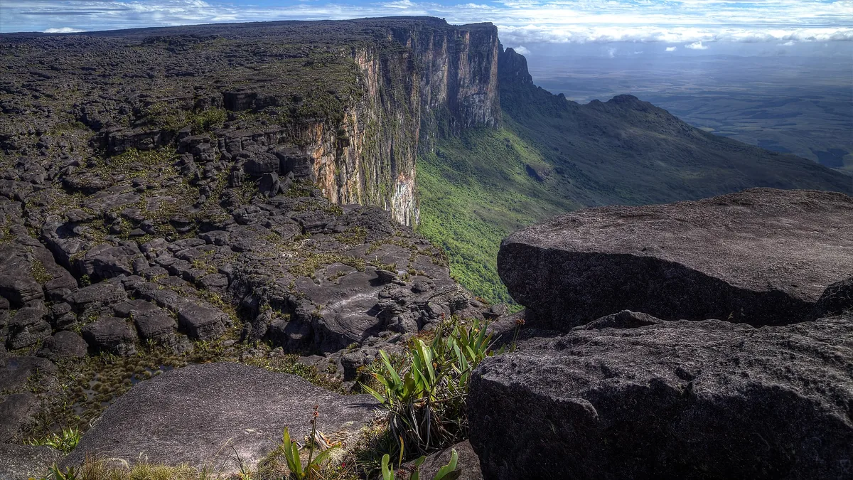
The table mountains of the Guiana Highlands in northern South America are the most dramatic expression of the process anywhere. These are sandstone plateaus rising a thousand metres or more above the surrounding forest, with vertical or overhanging cliffs and summits that can be tens of square kilometres in area.
The rock is extremely old sandstone, part of a sequence laid down when the region was part of a much larger landmass. It is quartz-rich and highly resistant, which is why it survives at this scale while the rock around it has been stripped away entirely.
The summits are isolated in a way that matters biologically. A tepui summit is an island in every sense that matters to a plant or an animal: surrounded by hundreds of metres of cliff, with a different climate and different soils from the forest below. Species on one summit are frequently found nowhere else, and different tepuis host different assemblages even when they are close together.
This isolation is not incidental. The summits have been separated for millions of years, which is long enough for independent evolution to produce the distinctive communities found there. Carnivorous plants, endemic frogs and unique invertebrates are the characteristic result.
Other famous examples
The flat-topped mountain above Cape Town is the same phenomenon with a different rock: a hard sandstone cap over softer material, with spectacular cliffs where the resistant layer is exposed. What makes it unusual is its position at the edge of a continent, which is why the sea is visible from the summit and why its silhouette is so recognisable.
The sandstone plateaus of the Sydney region in Australia are another instance on an enormous scale, where a hard sandstone sequence produces cliff lines, flat plateau tops and a landscape of deeply incised valleys between sheer walls.
In the American Southwest, the combination of a resistant cap and arid conditions produces the classic mesa-and-butte country, and also produces features such as natural arches and alcoves where the softer layer beneath the cap is eroded away and the cap eventually collapses in places.
Why the cliffs are vertical
The near-vertical faces of table mountains are a direct consequence of the same rock properties. A well-cemented sandstone or quartzite is strong in compression and has vertical fractures — joints — that water exploits. Erosion removes blocks along those joints rather than wearing the face back gradually, and the result is a cliff that retreats by collapse rather than by rounding.
The debris that falls accumulates at the base as a talus slope, which slightly protects the foot of the cliff from further attack. This is why many table mountains show a characteristic profile: a vertical upper cliff, a talus slope below it, and then the gentler slopes of the soft rock underneath.
Sapping helps too. Where water percolates through the caprock and emerges at the contact with the softer layer below, it undermines the cliff from within. Springs at that contact are common, and the wetting and drying cycle at the base accelerates the collapse of the face above.
What happens on top
The summit of a table mountain is not stable either, just slower. Rain falling on bare sandstone infiltrates rather than running off, because the rock is permeable and fractured. That water re-emerges at the cliff rim, which is why summit edges often have springs and why the vegetation at the rim can be different from the vegetation in the middle.
On sandstone summits the soils are typically thin, acidic and nutrient-poor, because quartz sandstone weathers into quartz sand and not much else. This is a major reason summit floras are specialised: the plants that survive there are the ones that can cope with very low nutrient availability and frequent waterlogging in depressions where drainage is poor.
Depressions on the summit can hold water in impermeable layers and form pools or bogs, which on tepuis have their own specialised communities. The combination of poor drainage, low nutrients and isolation is what makes these summit ecosystems distinctive globally.
Reading one in the field
Look for the contact. On almost any table mountain you can identify the boundary between the resistant cap and the softer rock beneath it, usually marked by a change in colour, a change in slope, and frequently a line of springs or seepage. That contact is the reason the mountain has a flat top.
Look at the talus below the cliff and at the blocks in it, which tell you what the caprock is made of. Look at the summit surface for evidence of what it originally was — bedding, ripple marks or cross-bedding in exposed sandstone are records of the environment that deposited it.
Finally, look outward. If there are other flat-topped remnants at the same elevation in the distances, they were once continuous. Reconstructing that surface in your head is how you work out how much rock has been removed from the landscape, and it is often a startling number.
Conclusion
A flat-topped mountain is a hard horizontal layer that outlasted everything around it. The summit is an old depositional surface, the cliffs are where the soft rock beneath has been stripped away, and the sequence from plateau to mesa to butte to pinnacle is the record of that stripping in progress. Tepuis take it to an extreme and have been isolated long enough to evolve their own species on top. Find the contact between caprock and soft rock, read the talus and the summit surface, and look for other remnants at the same level — that is how you reconstruct the plateau that used to be there.
Keep reading
Beyond Machu Picchu: 8 Inca Sites Almost Nobody Visits
Choquequirao, Wari terraces and fortress complexes that see a fraction of Machu Picchu's visitors. Where they are and what the hike involves.
Europe's Deepest Canyon Is Not Where You Think: The Tara River Gorge
The Tara River Canyon cuts deeper than most famous European gorges. How it formed, how it compares to the world's big canyons and how to see it.
New Zealand's Great Walks: The Four Almost Nobody Books
Most hikers book the Routeburn and Milford. These four Great Walks get a fraction of the traffic with the same alpine and coastal scenery.
